
Page 35 - Monaco Economy 120
P. 35
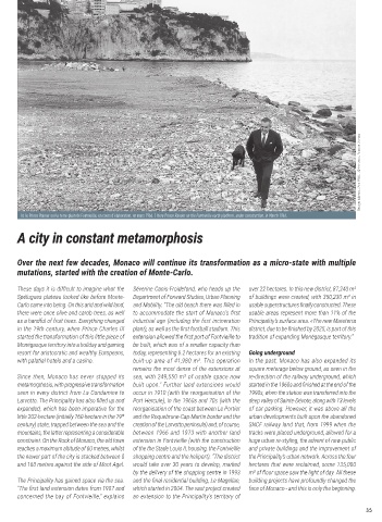
Georges Lukomski - Mars 1966 - L © Archives du Palais de Monaco


            Ici le Prince Rainier sur le terre-plein de Fontvieille, en cours d’élaboration, en mars 1966. / Here Prince Rainier on the Fontvieille earth platform, under construction, in March 1966.

           A city in constant metamorphosis


           Over the next few decades, Monaco will continue its transformation as a micro-state with multiple
           mutations, started with the creation of Monte-Carlo.

           These days it is difficult to imagine what the   Séverine Canis-Froidefond, who heads up the   over 22 hectares. In this new district, 87,240 m²
           Spélugues plateau looked like before Monte-  Department of Forward Studies, Urban Planning   of buildings were created, with 350,230 m² in
           Carlo came into being. On this arid and wild land,   and Mobility. “The old beach there was filled in   usable superstructures finally constructed. These
           there were once olive and carob trees, as well   to accommodate the start of Monaco’s first   usable areas represent more than 11% of the
           as a handful of fruit trees. Everything changed   industrial age (including the first incineration   Principality’s surface area. «The new Mareterra
           in the 19th century, when Prince Charles III   plant , as well as the first football stadium. This   district, due to be finished by 2025, is part of this
           started the transformation of this little piece of   extension allowed the first port of Fontvieille to   tradition of expanding Monégasque territory.”
           Monégasque territory into a holiday and gaming   be built, which was of a smaller capacity than
           resort for aristocratic and wealthy Europeans,   today, representing 6.2 hectares for an existing   Going underground
           with palatial hotels and a casino.    built-up area of 41,980 m². This operation   In the past, Monaco has also expanded its
                                                 remains the most dense of the extensions at   square meterage below ground, as seen in the
           Since then, Monaco has never stopped its   sea, with 249,550 m² of usable space now   re-direction of the railway underground, which
           metamorphosis, with progressive transformation   built upon.” Further land extensions would   started in the 1960s and finished at the end of the
           seen in every district from La Condamine to   occur in 1910 (with the reorganisation of the   1990s, when the station was transferred into the
            arvotto. The Principality has also filled up and   Port Hercule), in the 1960s and 70s (with the   deep valley of Sainte-Dévote, along with 13 levels
           expanded, which has been imperative for the   reorganisation of the coast between Le Portier   of car parking. However, it was above all the
           little 202-hectare (initially 160-hectare in the 19 th  and the Roquebrune-Cap-Martin border and the   urban developments built upon the abandoned
           century) state, trapped between the sea and the   creation of the Larvotto peninsula) and, of course,   SNCF railway land that, from 1999 when the
           mountains, the latter representing a considerable   between 1966 and 1973 with another land   tracks were placed underground, allowed for a
           constraint. On the Rock of Monaco, the old town   extension in Fontvieille (with the construction   huge urban re-styling, the advent of new public
           reaches a maximum altitude of 60 metres, whilst   of the the Stade Louis II, housing, the Fontvieille   and private buildings and the improvement of
           the newer part of the city is stacked between 0   shopping centre and the heliport). “The district   the Principality’s urban network. Across the four
           and 160 metres against the side of Mont Agel.   would take over 30 years to develop, marked   hectares that were reclaimed, some 135,000
                                                 by the delivery of the shopping centre in 1993   m² of floor space saw the light of day. All these
           The Principality has gained space via the sea.   and the final residential building,  e Magellan,   building projects have profoundly changed the
           “The first land extension dates from 1907 and   which started in 2004. The vast project created   face of Monaco - and this is only the beginning.
           concerned the bay of Fontvieille,” explains   an extension to the Principality’s territory of

                                                                                                                             35