
Page 39 - Monaco Economy 120
P. 39
Le jumeau numérique aide désormais à anticiper les décisions ur- construction, des fonctions sont associées à cette enveloppe numérique :
banistiques ? le modèle de trafic, les réseaux de fluides et énergétiques, le transport
On appelle jumeau numérique la représentation numérique de la Prin- public, etc. Des systèmes d’informations géographiques ont été mis
cipauté dans sa forme et certaines de ses fonctions. Des informations en œuvre par les services de l’administration (arbres, bâtiments, etc.),
issues de data (réseaux, foncier, etc.) ou de capteurs (chantiers, circu- des boucles de comptage de véhicules et de piétons sont actives, des
lation, etc.) peuvent être associées aux formes et fonctions qui y sont capteurs sont positionnés sur le territoire.
représentées. L’objectif est de pouvoir réaliser des investigations de
nature prospective ou de la simulation. En matière d’urbanisme, le jumeau numérique est déjà largement utilisé
La forme est la représentation 3D de l’enveloppe terrestre et de la pour explorer des formes urbaines et des insertions volumétriques dans
volumétrie des bâtiments, aussi détaillée que possible et texturée sur le paysage urbain. Il a été utilisé également pour formaliser le cadastre
la base de photo ou de représentations réalistes des objets (mobilier solaire de la Principauté, ou encore calculer la propagation du bruit des
urbain, espaces publics, végétation, etc.). Au fur et à mesure de leur véhicules dans les rues.
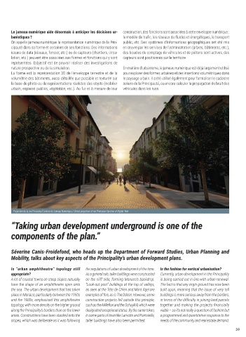
Projection de la rue Princesse Caroline du Jumeau Numérique / Street projection of rue Princesse Caroline of Digital Twin
“Taking urban development underground is one of the
components of the plan.”
Séverine Canis-Froidefond, who heads up the Department of Forward Studies, Urban Planning and
Mobility, talks about key aspects of the Principality’s urban development plans.
Is “urban amphitheatre” topology still the regulations of urban development of the time. Is the fashion for vertical urbanisation?
appropriate? As a general rule, taller buildings were constructed Currently, urban development in the Principality
A lot of coastal towns on steep slopes naturally on the cliff side, forming Monaco’s backdrop. is being carried out in line with urban renewal.
have the shape of an amphitheatre open onto “Look-out post” buildings at the top of valleys, The fact is that any virgin ground has now been
the sea. The urban development that has taken as seen at the Tête de Chien and Mont Agel are built upon, meaning that the issue of very tall
place in Monaco, particularly between the 1950s examples of this, as is The Odéon. However, some buildings is more serious away from the borders,
and the 1980s, emphasised this amphitheatre construction projects fell outside this principle, in terms of the difficulty in joining land parcels
topology, with more density on the higher ground such as the Millefiori and the Schuylkill, which were together and making the projects financially
along the Principality’s borders than on the lower designated exceptional status. By the same token, viable – so it’s not really a question of fashion but
areas. Constructions have been stacked onto the in some parts of town like Larvotto and Fontvieille, a programmed and quantitative response to the
slopes, which was deliberate as it was following taller buildings have also been permitted. needs of the community and real estate demand.
39